
How a Drone Survey Helps Prevent Drainage Problems
When a Drone Survey Helps Before Drainage or Site Work
Water problems usually start before construction begins.
A property may look flat during a quick visit. The grass looks clean. The ground feels dry. Nothing seems wrong at first.
Then site work starts.
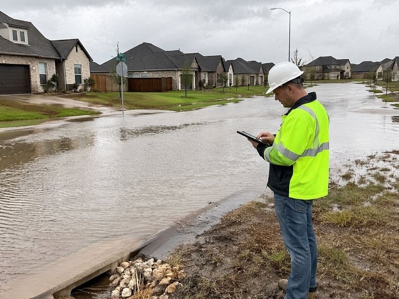
After the next heavy rain, water begins to collect near the driveway. Soil washes toward the road. One corner of the lot stays wet for days. Contractors suddenly need to change the grading plan.That happens more often than people think.
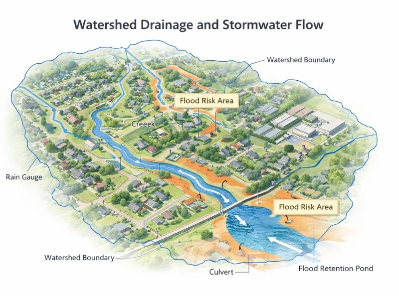
A drone survey helps show how water moves across the land before drainage or site work begins. It gives engineers and contractors a better view of slopes, low spots, and elevation changes that are hard to notice from the ground.
Why Drainage Problems Start Before Construction
A drone survey helps identify drainage issues before construction starts by mapping elevation changes, runoff paths, and low areas across a property. This helps contractors plan grading and stormwater work early, which reduces delays, standing water, erosion, and expensive drainage fixes later.
Many drainage problems already exist before a project begins.
The trouble is that most sites do not show those problems right away. A property can appear level while still having small elevation changes that affect runoff during storms.
That matters in Pensacola.
Heavy rain can move quickly across low ground. Sandy soil drains differently from compact clay. Some lots hold water longer after storms, especially near wooded sections or undeveloped land.
Without survey data, contractors often rely on visual judgment. That creates mistakes.
Water may flow toward:
- driveways
- future foundations
- sidewalks
- neighboring lots
- retention areas
Small grading errors can create large drainage problems later.
That is why many engineers now use drone survey data before clearing or excavation begins.
What a Drone Survey Shows Before Site Work
A drone survey creates a detailed aerial map of the property before grading or drainage work starts. It shows slopes, elevation changes, runoff paths, disturbed soil, and low areas that may affect stormwater flow or future construction.
Drone surveys collect information from above the property.
The drone flies across the site and captures overlapping images from different angles. Survey software then combines those images into a detailed map of the land.
That map helps reveal conditions that are difficult to see while standing on the ground.
A drone survey can show:
- drainage flow paths
- low sections of the property
- uneven grading areas
- slope direction
- existing structures
- tree coverage
- disturbed ground
- water collection areas
This information helps engineers create better drainage plans and supports topographic mapping services before construction begins. .
Even a few inches of elevation change can affect stormwater movement during heavy rain.
If the grading plan misses one low section, water may collect near pavement or structures after the project is complete.
Fixing that later costs far more than finding the issue early.
Why Drone Surveys Help During Grading Projects
Drone surveys help grading projects move faster because contractors can see accurate site conditions before moving dirt or installing drainage systems. Early survey data reduces rework, prevents grading mistakes, and helps crews prepare for drainage problems before construction equipment arrives.
Site work moves quickly once construction starts.
Excavators, graders, and drainage crews all follow a schedule. If the drainage plan changes halfway through the project, delays spread fast.
That increases labor costs and equipment time.
Drone surveys help reduce those changes by giving contractors better site information before grading begins.
This becomes useful during:
- stormwater planning
- utility layout
- driveway preparation
- drainage installation
- fill dirt calculations
- slope adjustments
Some properties need more grading than expected. Others need extra drainage structures after water flow becomes clear.
Without good survey data, crews may discover those problems too late.
That is when projects slow down.
Hidden Drainage Problems Are Easy to Miss
Drone surveys help reveal drainage issues hidden by trees, brush, uneven terrain, or undeveloped ground. The aerial view often shows runoff patterns and low pockets that are difficult to identify during a normal site visit.
Some drainage problems stay hidden until construction disturbs the land.
That is common on large properties and wooded lots around Pensacola.
Brush, trees, and uneven ground can hide natural drainage paths. Water may already move through the site during storms, but nobody notices until clearing work begins.
A drone survey helps expose those patterns early.
The aerial images often show:
- shallow swales
- runoff channels
- soft ground
- erosion paths
- standing water pockets
Those conditions matter before pavement, concrete, or foundations go into place.
Poor drainage can damage asphalt, weaken soil, and create erosion around structures. Standing water also creates long-term maintenance problems after construction finishes.
Nobody wants to discover those problems after the project is complete.
Why Large Properties Benefit From Drone Surveys
Drone surveys work especially well on large properties because they capture the full site faster than ground crews alone. This helps engineers and contractors study elevation changes, drainage flow, and grading needs across the entire property before construction starts.
Large sites take time to inspect from the ground.
Some areas may also be difficult to reach because of mud, brush, or uneven terrain. Walking the property may still miss drainage patterns hidden across the site.
A drone can capture the full property much faster.
That helps during:
- subdivision planning
- roadway preparation
- commercial site work
- utility corridor planning
- retention pond layout
Large properties usually contain more elevation changes across different sections of land.
A slight slope on one side of the property may affect drainage much farther away than expected.
That is why aerial survey coverage matters during early planning.
Why Homeowners Use Drone Surveys Too
Homeowners use drone surveys before drainage repairs, driveways, additions, and backyard projects because the aerial data helps explain how water moves across the property and where grading problems may exist.
Drone surveys are not only for large commercial projects.
Many homeowners use them before:
- building additions
- installing pools
- improving drainage
- clearing land
- adding driveways
- preparing backyard structures
Some owners already know they have drainage trouble. Others discover problems after strong storms flood part of the yard.
A drone survey helps show where the water starts collecting and how runoff moves through the property.
Without survey data, people often spend money fixing the wrong section of the yard.
Why Timing Matters Before Site Work Begins
The best time for a drone survey is before grading or construction changes the property. Early survey data helps engineers study natural drainage conditions before excavation removes the original runoff patterns across the site.
Timing matters during site preparation.
Once grading begins, the original drainage conditions start to disappear. That makes it harder to understand how water naturally moved across the property before construction.
Early survey data gives engineers a clearer starting point.
That helps create better drainage plans before equipment arrives on-site.
It also helps contractors avoid costly changes later in the project.
Drainage problems become much harder to fix after grading, pavement, and structures are already in place.
Before Site Work Begins
Drainage problems rarely appear out of nowhere. Most of the time, the warning signs already exist before construction starts. The problem is that many of those issues stay hidden from ground level.
A drone survey helps uncover those conditions early.
That gives engineers, contractors, and property owners a clearer view of how the land actually behaves before grading or drainage work begins. Small elevation changes, runoff paths, and low spots may seem minor at first, yet they can create expensive problems later if nobody catches them early.
Good site work starts with good information.
A drone survey helps reduce guesswork before construction changes the property for good.