
Topo Survey Before Grading a Lot That “Looks Flat”
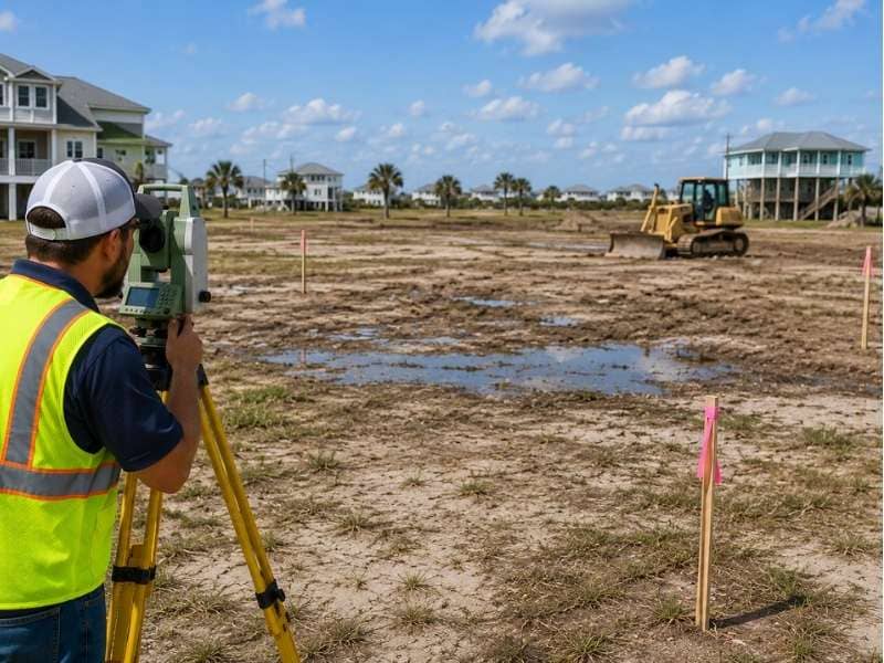
A lot can look perfectly flat and still cause big problems after construction begins. The ground may have small high and low spots that are hard to see just by walking around. A topo survey measures those differences in height across the whole lot. That information helps property owners and builders understand what they are actually working with before any grading starts.
Why a Topo Survey Can Find High and Low Spots on a Lot
A topographic survey is a detailed height measurement of a piece of land. Surveyors take readings at many points across the lot and record the elevation at each one. Those readings get combined into a picture of how the land rises and falls across the lot.
Even on a lot that looks flat, small height differences exist. A spot that is six inches lower than the rest of the yard may not be obvious when you walk across it. But six inches is enough to collect standing water after a rainstorm. A one-foot rise near the edge of a lot can block water from draining off the property.
These small changes in height matter a lot during construction. Where a slab gets poured and where a driveway goes both depend on the shape of the land. So does how soil gets moved around during construction. A topo survey gives builders that information in detail before work begins.
How a Topo Survey Helps Explain Why Water Stays on Flat Lots
Flat lots near the coast often have poor drainage. The land does not slope enough to move water away on its own. After a heavy rain, water has nowhere to go and sits on the surface until it slowly soaks in or evaporates.
A topo survey shows exactly where the low spots are on a lot. These are the places where water flows to and collects. On a lot that looks even from the street, a topo survey might find a shallow bowl shape in the middle. That bowl holds water after every rain. It might show that one corner sits slightly lower than the rest, pulling water toward a fence or a foundation.
Knowing where water collects helps engineers design drainage before grading changes the land. Without a topo survey, a builder might grade the lot in a way that makes drainage problems worse or creates new ones. Finding out where the water goes before moving any soil saves a lot of trouble later.
Why a Topo Survey Should Come Before Grading Work Starts
Grading means shaping the land by moving soil from one place to another. It prepares a lot for a building pad, a driveway, or a parking area. It also helps move water in the right direction. Grading changes the shape of the land, sometimes a little and sometimes a lot.
The problem with grading a lot without a topo survey is that the work is based on guesses instead of facts. A contractor might cut down a high spot and fill a low spot without knowing how that affects drainage. That change can push water onto a neighbor’s yard. Water that used to drain toward the street might now drain toward a neighbor’s yard.
A topo survey gives the engineer or contractor accurate height data to work with. They can look at the survey and plan where soil needs to go to create proper drainage and a good building site. The grading plan comes from real numbers, not from what the lot looks like on a quick walk-through.
Getting a topo survey before grading also creates a record of what the land looked like before any work was done. That record can be useful later if questions come up about drainage or lot conditions.
What a Topo Survey Can Show Beyond the Shape of the Land
A topo survey does more than record height. Surveyors also map features that are already on the lot. These can include trees, ditches, fences, driveways, utility poles, and any structures on or near the property.
Each of these features affects how the lot can be developed. A large tree near the center of a lot may have roots that spread far underground. Cutting into those roots during grading can damage or kill the tree and may also affect how the surrounding soil behaves. A ditch along the edge of the property may be part of a drainage system that serves more than one lot. Filling it in without permission can create problems for neighbors and may violate local rules.
Knowing where these features are before planning begins helps avoid surprises. An engineer designing a grading plan can work around a tree instead of through it. A builder can plan the driveway to miss the ditch. A surveyor can flag structures that might affect setback requirements.
The topo survey puts all of this information in one place. It shows the shape of the land and the things on it together. That gives property owners and builders a full picture of the site.
How Land Surveyors Use a Topo Survey to Plan Better Sites
A land surveyor collects elevation data by using leveling equipment or GPS tools that measure height with high accuracy. The surveyor takes readings at a grid of points across the lot and along the edges. Any spots where the land changes shape get recorded too.
After collecting the data, the surveyor puts it together into a drawing that shows lines called contours. Each contour line connects points that share the same height. When contour lines are close together, the land changes height quickly. When they are spread apart, the land is nearly flat. A builder or engineer reading a topo drawing can see the shape of the whole lot at once.
This drawing becomes a working tool for the project team. The civil engineer uses it to design drainage and grading. The architect uses it to figure out where the building should sit and how the foundation should be designed. The contractor uses it to plan how much soil needs to move and where it should go.
A topo survey done before grading starts gives everyone on the project the same accurate information. That shared starting point helps avoid mistakes. It also reduces the chance of drainage problems after construction and keeps the project moving with fewer surprises.
Frequently Asked Questions
Why should I get a topo survey before grading a lot that looks flat?
A topo survey shows small height differences that are hard to see just by looking at the land. Even a few inches can affect where water goes and how the lot drains. Having this information before grading starts helps avoid drainage problems and costly changes later.
How can a topo survey help with drainage problems?
A topo survey shows where the land is higher and lower across the whole lot. That tells engineers where water will flow and collect after rain. They can use that information to design drainage before grading changes the shape of the land.
Why do some flat lots have poor drainage?
A lot that looks level can still have low spots where water collects. The land may not slope enough to move water toward a street or ditch. A topo survey finds these spots and shows how water moves across the property.
What kinds of features can a topo survey show?
A topo survey can show ditches, trees, fences, driveways, utility poles, and existing structures. It also shows changes in elevation across the lot. These details help property owners and builders plan grading and construction with fewer surprises.
How do land surveyors use a topo survey when planning a project?
Surveyors collect height readings at many points across the lot and combine them into a drawing that shows the shape of the land. Engineers and builders use that drawing to plan grading, drainage, and building placement before any work begins.