
Flood Survey Questions Homeowners Ask After a Heavy Rain Event
Heavy rain can leave a yard full of standing water, wet spots near the foundation, and soggy ground that takes days to dry out. After a storm like that, most homeowners want to know why it happened and whether it will happen again. A flood survey helps answer those questions. It looks at the land, the water, and the conditions that affect how a property drains.
What a Flood Survey Can Tell You After Heavy Rain
A flood survey gives homeowners a clearer picture of what happened to their property during and after a storm. It looks at how high the water got, where it went, and which parts of the land were most affected.
Surveyors take height readings across the property and compare them to nearby drainage paths, ditches, and streets. That comparison shows how the land and the storm interacted. A homeowner might see water in the backyard for two days and not know why. A flood survey helps figure out if the cause is a land problem, a drainage problem, or both. A flood survey helps sort that out.
The survey also provides a written record. If flooding happens again, the survey data gives the homeowner something concrete to point to. It also helps with documentation for repairs or claims.
How a Flood Survey Helps Find Areas Where Water Collected
Not all parts of a yard flood for the same reason. Some areas sit lower than the rest of the property. Others have soil that soaks up water slowly. Some spots are near pipes or ditches that back up during heavy rain. A flood survey can help identify which of these is causing a problem in a specific spot.
Surveyors measure the height of the land at many points across the property. When those readings get mapped out, low spots show up clearly. A bowl-shaped area in the middle of a yard may be just a few inches lower than the ground around it. That is enough to pull water toward it and hold it there long after the rain stops.
Some low spots are easy to see after a storm because the grass is still wet or the soil is soft. Others are not obvious at all until the survey data shows them. Finding these areas gives homeowners something to work with when planning fixes or talking with a drainage contractor.
Why a Flood Survey Can Help You Understand Future Flood Risk
A flood survey does more than explain what already happened. It also gives homeowners information about which parts of their property are most likely to flood again.
Low areas that collected water once will collect it again under similar conditions. A flood survey maps those areas and records their exact height. That data shows how much the land would need to change to move water away from those spots. It also shows whether the problem starts on the homeowner’s own lot or comes from drainage patterns that cross several properties.
Coastal areas that receive heavy rainfall face these questions often. Rain totals can be high in these areas. Coastal land also tends to be low and flat. That makes it harder for water to move off a property quickly. A flood survey puts real numbers behind the risk. Homeowners are not left guessing about where the next problem will show up.
This information also helps homeowners have more useful conversations with engineers or local drainage officials. Instead of just describing what the yard looked like, they can show a survey with real data about the land.
How a Flood Survey Supports Drainage Discussions With Local Officials
Heavy rain and flooding are common concerns in many coastal communities. After a significant storm, homeowners often want to talk to local officials or drainage authorities about what can be done. Those conversations go better when the homeowner has accurate survey data to share.
A flood survey gives officials specific information about the property. It shows the height of low spots, how the land slopes, and how close the flooding came to the foundation. That information is more useful than a description of what the yard looked like after the storm.
Some drainage systems cross multiple properties. A flood survey can help show whether the problem starts on the homeowner’s lot or comes from somewhere else. Knowing that difference matters when deciding who needs to take action and what kind of fix makes sense.
Some drainage and permitting offices also ask for elevation data when homeowners apply for improvements or modifications to their property. A flood survey that includes elevation readings can support those applications and help move the process along.
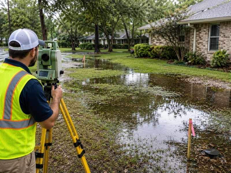
How Land Surveyors Use a Flood Survey to Study Water Movement
A land surveyor studying a property after flooding starts by collecting height readings at many points across the lot. These readings show the shape of the land in detail. When the surveyor connects those readings, they can trace the path water would follow as it moves across the property.
Water always flows from higher ground to lower ground. A surveyor uses the elevation data to follow that path from wherever the rain falls to wherever the water ends up. That path might cross the yard in a straight line. It might curve around a raised area or follow a low spot along a fence line. Water might also collect near a corner of the house.
The surveyor also looks at features on the property that affect how water moves. A raised flower bed near the house can act like a small dam. It can push water toward the foundation instead of away from it. A low area along the property edge might be the right place for a swale. A swale is a shallow channel that guides water away from structures.
After gathering the data, the surveyor can explain where the water came from and where it went. They can also describe what the land would need to look like to drain better. That explanation gives the homeowner and any contractors involved a shared understanding of the problem before any work begins.
Frequently Asked Questions
What information can a flood survey provide after a heavy rain event?
A flood survey shows how high the water got, where it collected, and which parts of the property were most affected. It also records the shape of the land, which helps explain why some areas flooded and others did not.
How does a flood survey help explain why water stayed in my yard?
A flood survey measures the height of the land at many points across the property. That data shows low spots and other features that pull water toward them and hold it after rain stops. Knowing where those spots are helps explain why some areas stay wet longer than others.
Can a flood survey help me understand future flood risk?
Yes. The low areas that flooded once are likely to flood again in similar conditions. A flood survey maps those areas and records their height. That shows how much the land would need to change to drain better. That information helps homeowners plan fixes and have more useful conversations with drainage contractors or local officials.
How does a flood survey support drainage discussions with officials or contractors?
A flood survey gives specific numbers about the property, including the height of low spots, how the land slopes, and how close the water came to structures. Officials and contractors can use that data to understand the problem and suggest fixes that fit the actual conditions on the ground.
How do land surveyors perform a flood survey?
Surveyors take height readings at many points across the property and map the path water takes as it flows from higher ground to lower ground. They also look at features like raised beds, fences, and drainage channels that affect how water moves. The result is a detailed picture of the land and how it behaves during heavy rain.