
LiDAR Mapping for Developers Planning Around Stormwater Ponds
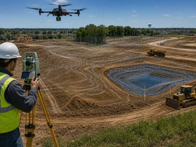
LiDAR mapping gives developers a clear view of the land before any dirt moves. It uses laser scans to map every rise and dip across a site. For a project that needs a stormwater pond, that detail matters a lot. Water follows the low ground, so knowing where the low ground sits shapes the whole plan. With good data early, a developer can place a pond where it works. That avoids costly fixes later.
See the Land Before Construction Begins
Before a crew breaks ground, a developer needs to know what the land is really doing. LiDAR mapping scans the site from the air and records millions of height points. The result is a clear model. It shows slopes, ridges, and dips that are easy to miss on foot. That model gives the team a solid base to plan from.
A clear picture early changes how the rest of the project goes. When the design starts from real ground data, fewer surprises show up during construction. The team can spot trouble spots, plan around them, and keep the work on schedule. Good data at the start saves time and money at the end.
Find Low Areas That Hold Water
Every site has spots where water wants to gather. LiDAR mapping finds them by measuring small changes in height across the whole property. A dip of even a few inches can decide where rain collects after a storm. Seeing these low areas first helps the team plan drainage that actually works.
- Shallow dips where rain pools after heavy storms
- Natural paths that carry runoff across the site
- Flat spots where water drains too slowly
- Wet ground that stays soft long after rain
- Areas that flow toward a neighbor’s land
Knowing these spots ahead of time gives a developer real options. The team can route water away from buildings and toward a planned pond. They can also keep roads and homes out of a spot that floods. That kind of planning is far easier before construction than after.
Improve Stormwater Pond Design
A stormwater pond only works if it sits in the right place and holds the right amount. LiDAR mapping shows where water naturally drains, which points to the best spot for the pond. The data also helps size the pond to match the runoff the site will produce. A pond built on guesswork can overflow or sit dry. A pond built on real data does its job.
Good elevation data also guides how water reaches and leaves the pond. The team can grade the land so runoff flows in smoothly. It then leaves in a safe, steady way. That cuts the risk of erosion, flooding, and failed inspections. Better data leads to a pond that protects the whole development.
Better Planning for Growing Areas
As more homes and roads go in, the ground handles water differently. Hard surfaces like pavement and rooftops send rain rushing off instead of soaking in. That extra runoff puts more pressure on every pond and drain in the area. Detailed land data helps a developer plan for that load. No one wants to be caught off guard.
Growth also means rules around stormwater tend to get stricter. Local reviewers often want proof. They need to see that a site can handle big storms without flooding nearby land. LiDAR mapping gives developers the solid numbers those reviews call for. Strong data makes approvals smoother and projects more dependable.
Turn Land Data Into Smarter Building Plans
Raw scan data is only useful when it shapes real decisions. Developers use LiDAR results to choose where homes, roads, and ponds should go. The data shows which areas are safe to build on and which should stay open for drainage. Each choice rests on facts instead of a hopeful guess.
Smarter plans also lower risk across the whole project. When a site drains well, there are fewer callbacks, fewer delays, and fewer angry neighbors. Buyers get a safer place to live, and the developer protects their good name. That is the real payoff of planning around solid land data.
Frequently Asked Questions
What makes LiDAR mapping different from a regular survey?
LiDAR mapping collects millions of height points across a whole site. That is far more than a basic survey record. That dense detail shows tiny changes in the ground that affect how water moves. For drainage and pond work, that level of detail makes a real difference.
Can LiDAR mapping work in wooded areas?
Yes, LiDAR can read the ground even when trees and brush cover it. The scan captures points between the leaves and branches to model the bare earth below. That makes it useful for wooded sites where water paths are hard to see by eye.
How accurate is LiDAR mapping?
LiDAR mapping captures the shape of the land in fine detail. That detail guides drainage and pond design. Small dips and slopes that the eye misses show up clearly in the data. That precision helps a developer plan water flow with confidence.
Is LiDAR mapping useful for drainage projects?
Yes, drainage work depends on knowing exactly where water flows, and LiDAR shows that path. The data reveals low spots, runoff routes, and slopes across the entire site. With that picture, a team can design ponds and channels that move water safely.
Who uses LiDAR mapping the most?
Developers, engineers, and site planners use LiDAR mapping most. They rely on it for grading and drainage work. It supports decisions about where to build and how to handle stormwater. Anyone planning around water flow gains from the detail it provides.
How long does LiDAR mapping take?
The flight to scan a site often takes only a few hours. Turning the data into a finished model takes longer. Most projects deliver usable results within one to two weeks. Larger or more complex sites can add time.