
Topographic Survey: What It Is and When You Need It
A topographic survey can reveal problems with your land before construction even begins. Imagine buying your dream property, starting a project, and then discovering major drainage issues, steep slopes, or unstable grading conditions that completely change your plans. That is exactly why understanding the land first is so important.
Many property owners assume a lot is flat and ready to build on just because it looks that way from the ground. However, hidden elevation changes can create expensive problems later. A topographic survey helps identify those issues early, so you can make smarter decisions before construction starts.
What Is a Topographic Survey?
A topographic survey maps the elevation, slope, and physical features of a property. It shows how the land rises and falls while identifying structures, trees, utilities, and drainage patterns. Engineers, architects, and contractors use this data to safely design construction projects, drainage systems, and site improvements before building begins.
A topographic survey is a detailed study of your land. It measures the shape of the ground, including hills, slopes, flat areas, and low spots where water may collect. It also maps important features already on the property, such as:
- Buildings
- Driveways
- Fences
- Trees
- Roads
- Utility lines
- Retaining walls
- Drainage areas
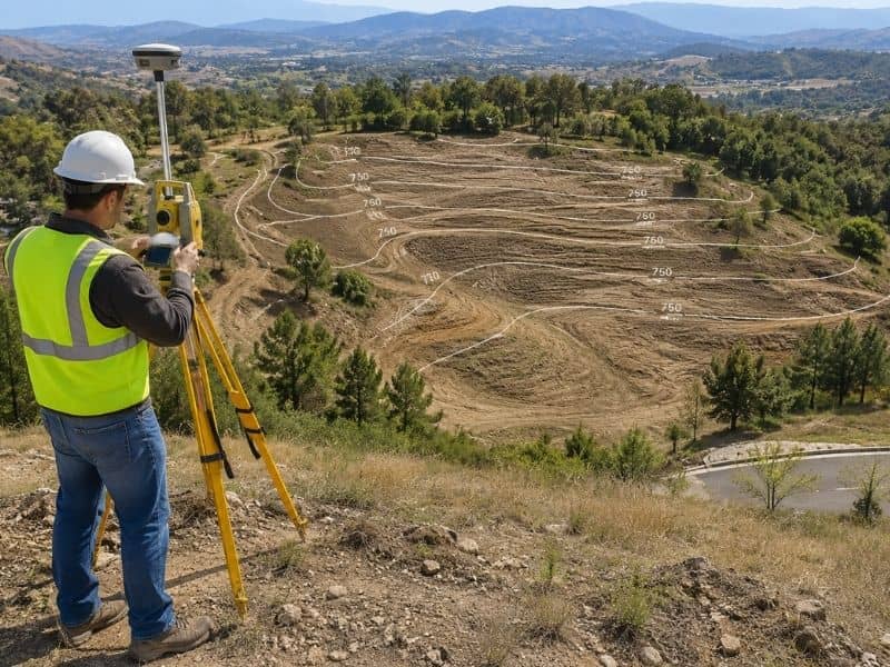
The final product is called a topo map. This map uses contour lines to show changes in elevation across the property. Lines that are close together show a steep slope, while lines farther apart show flatter ground.
Think of it as a bird’s-eye view of your property with elevation details included. It gives builders and engineers the information they need to design safely and correctly.
How Is a Topographic Survey Different from Other Surveys?
A topographic survey focuses on the shape and elevation of land, while a boundary survey identifies legal property lines. Both surveys are often used together during construction projects because one shows ownership boundaries and the other shows the physical conditions and terrain of the property.
Many people confuse topographic surveys with boundary surveys or ALTA surveys. While they are related, they serve different purposes.
A boundary survey focuses on:
- Property lines
- Corners
- Easements
- Encroachments
A topographic survey focuses on:
- Elevation
- Slopes
- Drainage flow
- Physical land features
- Surface conditions
In many construction projects, both surveys work together. One shows where your property begins and ends, while the other shows what the land is actually like.
When Do You Need a Topographic Survey?
You typically need a topographic survey before construction, land development, drainage improvements, subdivision projects, or major landscaping work. The survey helps identify slopes, elevation changes, and site conditions early so property owners can avoid expensive design problems, drainage failures, and construction delays later.
Here are some of the most common situations where a topographic survey is important.
Before Building a Home or Structure
Before construction starts, engineers and contractors need to understand the slope and layout of the land. Without accurate elevation data, they cannot properly design:
- Foundations
- Drainage systems
- Grading plans
- Driveways
- Utility layouts
Skipping this step can lead to water pooling, unstable foundations, and costly redesigns later.
Before Installing a Pool, Deck, or Retaining Wall
Even smaller outdoor projects need accurate grading information. Building on a slope without understanding the elevation can cause drainage problems and soil erosion.
For example, water may start flowing toward your home instead of away from it. That can lead to flooding, foundation damage, and expensive repairs.
When Solving Drainage or Flooding Problems
If your yard stays wet after heavy rain, a topographic survey can help identify the cause. Even small elevation changes can affect how water moves across a property.
Survey data helps engineers create proper drainage solutions instead of guessing where the problem starts.
According to the Federal Emergency Management Agency, poor drainage and grading issues can increase flood risks around structures. Elevation data plays an important role in managing stormwater safely.
Before Buying Raw or Rural Land
Undeveloped land may look simple at first. However, hidden slopes, drainage paths, and uneven terrain can make development much more expensive than expected.
A topographic survey helps buyers understand the true condition of the property before making a major investment.
During Land Development or Subdivision Projects
Most cities and counties require a topographic survey before approving subdivision or development plans.
The survey helps planners decide:
- Where roads should go
- How drainage systems should work
- Where utilities can be installed
- How to manage stormwater runoff safely
Without accurate elevation data, development plans may not meet local requirements.
What Happens During a Topographic Survey?
During a topographic survey, licensed land surveyors collect elevation and site data using GPS equipment, total stations, and drones. They measure natural and man-made features across the property and create a topo map that engineers and contractors use for planning and design purposes.
The survey process usually begins with a site visit. A licensed land surveyor collects measurements across the property using professional equipment such as:
- GPS systems
- Robotic total stations
- Drones
- LiDAR technology
Modern survey tools allow surveyors to collect highly accurate elevation data quickly and safely.
The surveyor measures:
- Ground elevations
- Buildings
- Trees
- Utility structures
- Drainage features
- Surface changes
After collecting the data, the surveyor creates a detailed topo map that architects, engineers, and contractors can use during design and construction.
Depending on the size and terrain of the property, the process may take several days to a couple of weeks.
How Much Does a Topographic Survey Cost?
The cost of a topographic survey depends on property size, terrain complexity, vegetation, accessibility, and location. Residential surveys may cost several hundred to several thousand dollars, but the investment often prevents much larger construction, drainage, and grading problems later in the project.
Several factors affect the cost of a survey, including:
- Property size
- Terrain difficulty
- Tree coverage
- Accessibility
- Amount of detail required
A small residential lot may cost much less than a large rural property with steep slopes and dense vegetation.
While the survey may seem expensive upfront, it often saves money in the long run. Fixing drainage or grading problems after construction can cost far more than getting accurate survey data before building starts.
Why Hiring a Licensed Land Surveyor Matters
A licensed land surveyor provides accurate measurements, follows state regulations, and delivers legally reliable survey data. Hiring a qualified professional helps reduce the risk of construction errors, permit issues, drainage failures, and costly redesigns caused by inaccurate elevation information.
Professional surveyors use calibrated equipment and follow strict standards when collecting data. They also understand local building requirements and development regulations.
Trying to estimate slopes or elevations without professional survey data can lead to:
- Permit delays
- Failed inspections
- Drainage issues
- Foundation problems
- Construction mistakes
- Expensive rework
Simply put, accurate survey data helps protect your investment.
Common Reasons Property Owners Request a Topographic Survey
Here are some of the most common reasons people order a topographic survey:
- Building a new home
- Planning a subdivision
- Solving drainage problems
- Installing a retaining wall
- Designing landscaping
- Preparing engineering plans
- Buying undeveloped land
- Improving stormwater drainage
- Planning utility installations
- Developing commercial property
Frequently Asked Questions
What is a topographic survey used for?
A topographic survey is used to map elevation changes, slopes, drainage patterns, and physical features on a property. It helps engineers, architects, and contractors design construction projects safely and accurately.
Do I need a topographic survey before building?
In many cases, yes. Builders and engineers need elevation data to design foundations, drainage systems, and grading plans properly before construction begins.
How long does a topographic survey take?
The timeline depends on the size and complexity of the property. Smaller residential surveys may take a few days, while larger or heavily wooded properties may take longer.
Can a topographic survey help with drainage problems?
Yes. A topographic survey identifies low spots, slopes, and water flow patterns that may be causing drainage or flooding issues on a property.
What is the difference between a boundary survey and a topographic survey?
A boundary survey identifies legal property lines, while a topographic survey maps the physical shape and elevation of the land.