
What Does a Construction Surveyor Do Before You Break Ground?
A lot can go wrong between buying a parcel and starting construction. Buildings get placed in the wrong spot. Setback lines get crossed. Grades get designed without accurate ground data. None of those problems are cheap to fix once a crew is already on site.
A construction surveyor prevents most of them. Before any digging starts, they verify site conditions, mark exact locations, and give your whole project team a shared set of accurate numbers to work from.
This article covers what a construction surveyor does before ground breaks, why it matters, and what happens when developers skip or rush the process.
What Is a Construction Surveyor?
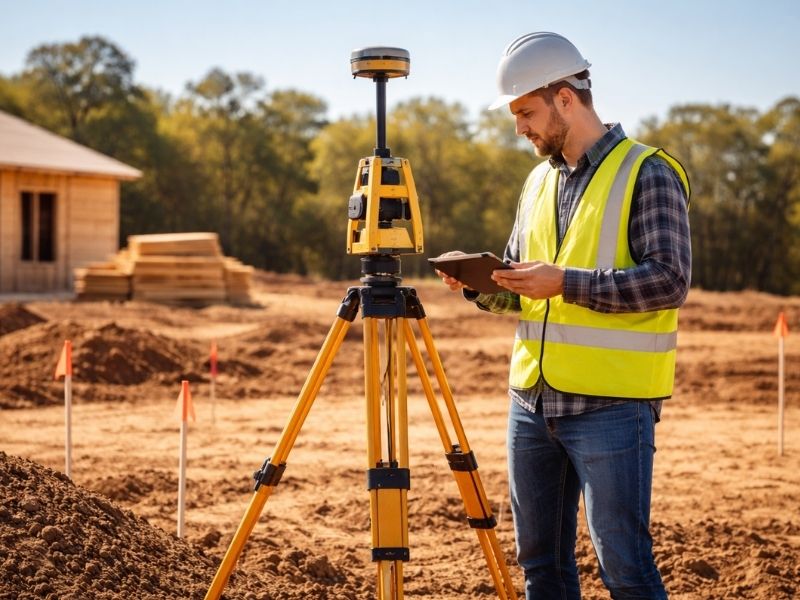
A construction surveyor is a licensed professional who measures and marks a site to support building work. Their job starts before construction and continues through each phase until the project is complete.
They work from approved plans and legal records. Their measurements tell contractors exactly where to build, how deep to dig, and how high to grade.
Without that guidance, crews make decisions based on guesses. That’s when costly mistakes happen.
What a Construction Surveyor Does Before Ground Breaks
Pre-construction survey work covers several tasks. Each one directly affects what happens once the job starts.
Reviewing Site Plans and Legal Records
Before touching any equipment, the construction surveyor reviews the project drawings, site plans, and property records.
They check the approved plans against the legal description of the parcel. They confirm the property boundaries match what the design assumes. If there’s a gap between the two, they catch it before it becomes a field problem.
This step also identifies easements and setback lines that restrict where structures can go. A building placed inside an easement area may need to be relocated. Finding that on paper is far cheaper than finding it after a foundation is poured.
In Pensacola and Escambia County, older parcels and coastal properties often carry recorded easements that don’t show up clearly on standard property maps. A surveyor who knows the local records catches these early.
Establishing Site Control Points
Control points are fixed reference markers placed in the ground. Everything else on the site gets measured from them.
The construction surveyor places these markers at precise coordinates tied to the project’s survey datum. Engineers, contractors, and subcontractors all use the same control points throughout the job.
This keeps every trade working from the same reference. Without shared control points, different crews may measure from different spots and end up with conflicting results.
Staking the Building Location
Once control is set, the construction surveyor marks where the building goes.
Stakes or pins get placed at the corners of the structure, at the building lines, and along any other features called out in the plans. Crews use these stakes to position their work correctly.
The stakes show contractors exactly where to set forms, pour footings, and begin excavation. Move a stake by accident and the whole building shifts. That’s why staking gets done by a licensed surveyor, not a contractor guessing from a plan sheet.
Verifying Setbacks and Building Lines
Every parcel has required setbacks. These are minimum distances between structures and property lines, roads, or other features.
The construction surveyor confirms the proposed building location clears all setback requirements before work begins. If it doesn’t, the plans need to change before a permit gets issued or a foundation gets placed.
Setback violations can trigger stop-work orders, require demolition of completed work, or delay a certificate of occupancy. In Pensacola, where new residential and commercial development continues to expand into areas with tight lot layouts, setback verification before breaking ground is not optional.
Checking Existing Conditions Against the Design
Plans are based on information available at design time. Site conditions don’t always match.
The construction surveyor verifies existing grades, utilities, and site features against what the plans assume. If something is off, the design team gets notified before work starts.
A swale in the wrong place. A utility line closer to the surface than expected. A grade difference that changes the cut-and-fill calculation. These are the kind of conditions that derail projects when they show up mid-construction instead of before it.
Pensacola’s low-lying terrain and high water table make grade verification especially important. A small elevation error can affect drainage performance across the entire site.
Why Developers in Pensacola Shouldn’t Skip Pre-Construction Survey Work
Skipping pre-construction survey work saves money for about two weeks. Then it starts costing money in ways that are hard to budget for.
Mislabeled building corners lead to misplaced foundations. An incorrect grade assumption causes drainage problems after the slab is down. A missed setback violation means pulling permits and halting work until the issue gets resolved.
Every one of those outcomes is more expensive than the survey would have been.
What Happens When Staking Gets Done Too Late
Some developers order construction staking after excavation has already started. The crew digs based on rough field measurements, and the surveyor gets called in to confirm the location.
By then, if the location is wrong, material has already moved. The fix involves additional excavation, fill, or in some cases a redesign of the foundation layout.
Ordering staking before any earthwork begins is standard practice for a reason. It costs less and causes fewer delays.
How a Construction Surveyor Works With the Rest of the Project Team
The construction surveyor doesn’t work in isolation. Their data feeds directly into the work of every other party on the project.
Civil engineers use the pre-construction survey data to finalize grading plans and drainage design. Architects reference the staked building corners when reviewing site layout. Contractors use the control points and stakes as their daily reference for positioning work.
When the survey data is accurate and delivered early, the whole team moves faster. When it’s late or wrong, everyone slows down.
Good communication between the surveyor, the project manager, and the design team at the start of a job prevents most coordination problems before they start. For Pensacola projects subject to Escambia County permitting, having verified survey data ready before the permit submission can also shorten review times.
Frequently Asked Questions
Is a construction surveyor the same as a boundary surveyor?
No. A boundary surveyor establishes legal property lines. A construction surveyor uses those legal boundaries as a reference, then positions structures, grades, and improvements within the site according to the approved building plans. Both are licensed surveyors, but they handle different scopes of work.
When should a construction surveyor be brought in?
Before any earthwork or excavation begins. The surveyor needs to set control points and stake the building location before crews start digging. Waiting until after excavation starts increases the chance of mislocation and adds cost to fix mistakes.
Does a construction surveyor check the work during construction?
Yes. Pre-construction staking is the first step, but construction surveyors are also called back at specific stages to verify that work matches the plans. Foundation forms, structural elements, and grade checks all happen at different points in the project.
What does construction staking include?
Staking typically includes marking building corners, foundation lines, utility alignments, road centerlines, and grade stakes for earthwork. The scope depends on the project type and what the contractor needs to position their work correctly.
Can the general contractor do their own staking?
A contractor can make rough layout marks for internal coordination, but those marks are not a substitute for licensed survey staking. Legal permits, inspections, and final occupancy approvals are based on verified survey measurements, not contractor field estimates.