
Elevation Survey Data Contractors Need Before Setting Finished Floor Height
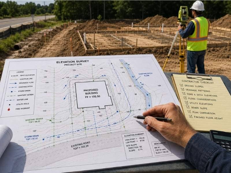
Before contractors pour the foundation, they need to know: how high should the finished floor be? Getting this wrong costs money and delays work. An elevation survey provides the data contractors need to set the floor at the right height.
Ground Height Around the Building Area
An elevation survey maps high and low spots across your property. The surveyor records ground elevation at dozens of points. Some spots may be two feet higher than others. Some areas may slope toward the building.
Contractors use this data to set the finished floor correctly. If ground slopes toward the building, the floor needs to be higher to prevent water pooling against the foundation. If one corner is lower, that corner needs extra attention.
Key reasons contractors need elevation data:
- Ground slopes vary across properties, affecting drainage
- Low spots create water collection zones near foundations
- Exact heights prevent guesswork about floor placement
A surveyor’s contour map shows your land’s shape in precise detail.
Nearby Roads, Ditches, and Drainage Paths
Water flows downhill following ditches and natural drainage paths. An elevation survey shows where water naturally goes on and around your property. Water can travel from nearby roads and ditches toward your building.
If the road is higher than your building site, water runs away. If the road is lower, water runs toward your site during heavy rain. Ditches direct water in specific directions.
Building on a site lower than nearby roads or drainage areas creates risk. Water will naturally flow toward your building during storms.
What contractors must consider:
- Road elevation and slope relative to the building
- Ditch location, depth, and water flow patterns
- Natural low spots that collect water
- Storm drain locations
This data helps contractors design the right floor height and plan proper drainage.
Safe Height Above Possible Floodwater
Every property has a certain flood risk. Some areas flood regularly. Others rarely see water issues. An elevation survey measures actual ground conditions. Contractors can compare this to known flood levels and historical water marks.
If the property is in a flood-prone area, the finished floor should be higher than the expected flood level. This protects the building’s interior and systems. Buildings built too low face water damage, mold, and structural problems.
Raising the floor costs money upfront but prevents far larger costs from water damage later. Insurance companies recognize higher floors and may offer lower rates.
How elevation data supports floor planning:
- Identifies properties in flood-prone areas
- Shows ground elevations compared to known flood levels
- Helps contractors design floors above water levels
- Reduces flood damage risk
Smart contractors compare survey data to historical flood information before finalizing floor heights.
Utility Heights That Affect Floor Level
Sewer lines, storm drains, and water lines must connect to the building. These utilities can’t flow uphill. They need the right slope so water and waste move away from the building. An elevation survey shows where underground utilities are located and at what depth.
If a sewer line is 10 feet below ground and your building is on high ground, the finished floor might need adjustment. The slope between the building and the sewer connection must work correctly. This is especially important for gravity-fed systems.
Contractors often discover utility conflicts after foundation work starts. An elevation survey done before construction prevents these costly surprises. The survey shows utility locations so the contractor can design a floor height that works with existing utilities.
Common utility factors:
- Sewer line depth and slope requirements
- Storm drain locations and elevations
- Water line connections and pressure zones
- Septic systems and drain field slopes
A good contractor reviews utility locations before setting floor height.
Plan Heights Compared With Real Site Heights
Building plans show a finished floor elevation, usually as a number like “105.5.” But what does the actual ground look like? An elevation survey shows real conditions. Contractors compare plan elevations with actual site data.
Sometimes they match perfectly. Often they don’t. The proposed floor height might be too high, too low, or just right. A mismatch means changes that cost time and money.
Contractors who review survey data before finalizing plans avoid major revisions. They catch problems early when changes cost less. A $500 survey now prevents $10,000 in foundation rework later.
Why early comparison matters:
- Reveals conflicts between plans and actual ground
- Allows design changes before construction starts
- Prevents costly foundation mistakes and delays
- Ensures utilities connect correctly to the building
Smart contractors always compare plans with survey data before breaking ground.
Frequently Asked Questions
What does an elevation survey show?
An elevation survey measures ground height across a property. The surveyor records spot elevations at key points and creates contour maps showing high and low areas. It identifies features like roads, ditches, and utilities that affect water flow and drainage.
Why do contractors need an elevation survey before setting floor height?
Contractors use elevation data to place floors at heights that prevent water damage and ensure proper utility connections. Without survey data, they guess about ground slopes and drainage. Guessing leads to costly mistakes.
Is an elevation survey important for low-lying land?
Yes. Low-lying properties need surveys urgently. This data shows how water collects, where drainage flows, and how high the floor must be to stay dry. The survey provides the data needed to build safely.
Can elevation data prevent foundation problems?
Yes. Knowing ground elevations helps contractors design foundations that handle water flow and allow proper utility slopes. Many foundation problems stem from water entering buildings built too low. Survey data prevents this.
What happens if contractors ignore elevation survey data?
They risk water damage, foundation cracks, utility problems, and expensive rework. Elevation data costs more upfront but avoids these hidden problems later. The survey expense saves money in the long run.